


The historical origins of astrocartography predate Jim Lewis. Long before planetary lines were drawn by software, European astrologers, scientists and geographers mapped celestial influences across space. This article uncovers early astrocartography in France, Switzerland, Canada and England.
This post is part of our three-part astrocartography series. In Blog 1, we explored how Jim Lewis formalised the method and built its digital rise. Here, we go deeper into the historical origins of astrocartography. We trace how early pioneers in France, Switzerland, Canada and England developed foundational ideas paving the way for Lewis’s innovations.
The English Contribution: Sepharial and the Geodetic Framework (1924)
This article continues the exploration of astrocartography’s origins introduced in Blog 1. We shift the spotlight from planetary angularity to the structural systems that made geographic astrology possible. Johndro and the Gauquelins laid conceptual and empirical foundations. But lesser-known figures, Sepharial and Volguine, built critical frameworks that predate Jim Lewis’s global system.
Sepharial (Walter Gorn Old, 1864-1929), was a British astrologer active in the early 20th century. He was the first to formalise the idea that each terrestrial location corresponds with a specific point on the zodiac. Widely credited with inventing the geodetic system, he aligned locations on Earth with zodiacal degrees. This wasn’t done by planetary motion, but by fixed spatial correspondence. Crucially, he based this model on the Prime Meridian running through Greenwich. His home country being official zero point for global time and longitude.
This historical context is not incidental. England formalised global timekeeping through the Greenwich Meridian in 1884. At the same time, Sepharial was pioneering an astrological model rooted in the same geographic logic. His geodetic map was a quiet revolution – offering astrologers a framework grounded in cartography rather than esotericism. It subtly recast astrology as a spatial science, foreshadowing the planetary mapping methods that would follow.
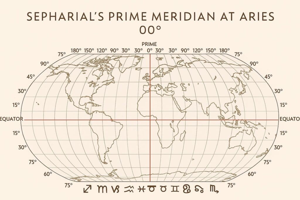
Often overlooked today, Sepharial’s geodetic system provided the mathematical foundation upon which later European innovators expanded, especially in France. And it is from this technical lineage, not a mystical one, that figures like Alexandre Volguine would soon emerge.
Edward L. Johndro: The Midheaven as Earth Anchor (1934)
In his seminal work “The Earth in the Heavens”, Canadian astrologer Edward Johndro advanced a theory of planetary resonance. He rooted his theory in electromagnetic field theory. He place the Midheaven (MC) at the centre of locational influence. His theory was that planetary energies could be mapped to specific points on Earth. He didn’t draw planetary lines on maps per se, but his thinking anticipated the geo-spatial logic behind Lewis’s later system.
Johndro’s language was also ahead of its time. He wrote about Earth grids, resonance fields, and energetic pathways. All concepts that still resonate today with serious locational astrologers who study geodetics, local space and in mundo techniques. In many ways, Johndro is the philosophical link between geodetics and astrocartography.
Alexandre Volguine and the First French AstroMaps (1938–1960’s)
In 1952, Alexandre Volguine published what may be the earliest known example of planetary mapping over a national territory in Les Cahiers Astrologiques. Unlike the more theoretical approaches of his contemporaries, Volguine offered a practical visual. A hand-drawn map of the world with superimposed zodiac signs and their planetary angles linked to specific regions.
A scanned reproduction of this map is featured below, preserving a rare historical document in the evolution of geographic astrology.
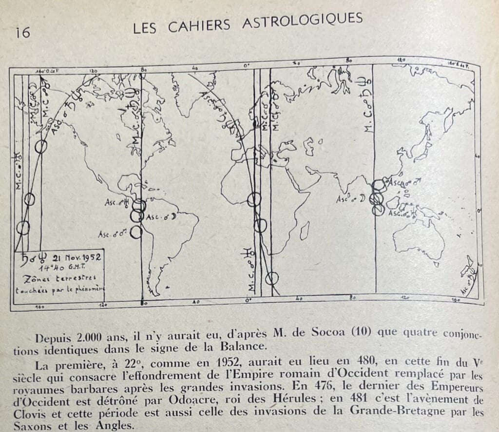
This proto-AstroMap reflected Volguine’s broader mission – to synthesise astrology with geography, culture, and national identity. His astrological cartography was not software-generated, but designed through intuition, observation and esoteric reasoning. In doing so, he foreshadowed the modern search for resonance between person and place.
Volguine’s work signals a transitional phase between symbolic geography and data-based geographic astrology. His map stood as a precursor to today’s astrocartography, revealing that the impulse to chart celestial influence across space existed decades before the computerised methods of Lewis.
The Gauquelins: Statistical Proof of Angles (1955–1970’s)
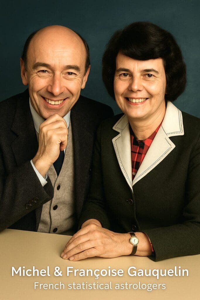
The Gauquelins’ research transformed speculation into data. Their studies revealed that planets located just after rising (AC) and culminating (MC) occurred more frequently in the charts of eminent individuals. These “plus zones” statistically validated the ancient claim that planets on the angles carry the most weight.
Their work is critical to astrocartography, which depends entirely on the principle that a planet on the AC, DC, MC or IC has magnified influence when experienced in that geographic location. The Gauquelins did not practice astrocartography – but they confirmed its angular logic.
Charles Jayne: The Technological Bridge (1950s–1960s)
Charles Jayne, USA (1911–1983), played a key transitional role in the history of modern locational astrology. A pioneer in applying computer technology to astrological calculations, Jayne helped bridge traditional techniques with emerging tools that made mapping planetary positions more precise. While he did not formalise astrocartography, his early use of geographic mapping and local space forecasts contributed to the technical framework Jim Lewis later perfected.
Unification of the Astrocartographic System by Jim Lewis (1970s–1980s)
What Jim Lewis achieved was unification. Drawing from these traditions – geodetics, relocated charts, Johndro’s angular theory, Gauquelin sectors – he created a complete and coherent system:
• Angular planetary lines mapped across the globe (AC, DC, MC, IC);
• A relocation-based reading method combining natal and relocated charts;
• Proprietary software and printed maps;
• A written “Cookbook” interpretation method;
• The Continuum certification and ethical practice code.
In 1981, he secured a US patent, protecting the technique as a complete system rather than a loose tool. Astrocartography became the first modern locational astrology method with standards, structure and public accessibility.
Legacy and Misunderstanding
Today, most critics of astrocartography are unaware of this history. Dismissals such as “too modern” or “lacking in tradition” overlook the century of work behind it. What Lewis created was never a spiritual fad – it was a culmination of intellectual, mathematical and geographic insight.
Astrocartography is a map, but it is also a method. And that method, while simplified in today’s software, remains grounded in serious technical traditions.
The next time someone tells you astrocartography is “just a TikTok trend,” tell them about the forefounders. Names like Sepharial, Johndro, Volguine, Gauquelin, Jayne and Lewis. Then show them the map.
Are you ready to explore the planetary influences beneath your feet? Do it with someone who understands both the chart and the terrain.
For those seeking long-term clarity, my Full Relocation Strategy, offers a comprehensive approach rooted in certified astrocartographic analysis.
→ Continue to Blog 3: Preserving the Legacy of Licensed Astrocartography


Comments +